 One of my first views of the topography. The highest mountain is around 2,500 feet. The spine of the ridge runs most of the length of the 20 mile long island.
 A view of the north shore of Tutuila. There are a few roads that run across the ridge to the north side from the much more populated south side.
 A typical village scene. The building on the right is a meetinghouse of sorts.
 The view of Pago Pago harbor and the cannery on the right. The main area of Pago Pago is set toward the back of the harbor.
I had a run-in with the police while I was there. I was looking for a pay phone (they are almost non-existent) and driving around town. I took a right turn off of the main road and as I started down the side road, I thought "this road doesn't seem wide enough for me and the car coming toward me." Then the blue lights came on and I was told to pull into an adjacent parking lot. The officer asked if I knew that I was traveling the wrong way on a one-way road. I told him that it was my first time in Pago Pago and that I did not see any signs indicating the one-way. He replied that there weren't any and it was "kind of a problem" I was let off with a warning...
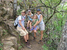
 This is part of the National Park of American Samoa. We drove to the point that you see in this scene (it was a half mile walk or so from the end of the road to the point.)
 The view at the point. Most of the shoreline is quite rocky. There are a few beaches.
 You can see the "rock hopping" fish on this rock that I noticed. As you got close they would jump from rock to rock. They are about 3 inches long or so.
Some of the things that I noticed...the people are very friendly! I'm glad that I am not a true vegetarian and will eat fish (it was most of my diet for the week). Many men wear lava lavas (think long kilt without the checkerboard) mostly solid patterns, but some aloha style. There is a starkist tuna cannery that is by far the biggest employer on the island. The public transport buses are great, brightly decorated, blasting hip-hop and generally jam packed with 20 people or so (about every 5th car on the island).
 The entrance sign to Fagatele Bay. We had a free afternoon to do some snorkeling. It's about a mile hike to a secluded beach. The coral was very beautiful! Not a lot of fish, but definitely some that I don't usually see in HI. I especially like the prohibition on dynamiting...
 There were breadfruit trees (seen here), bananas, and coconut trees absolutely everywhere!
 Fagatele Bay
 While we were at Fagatele Bay, we saw quite a few fruit bats (known as Flying foxes). We saw them here and there around the island, especially at dusk.
 Charlie the tuna.
 Our last meeting of the week was at American Samoa community college.
1 comment:
thanks for visiting
from pago
john
Post a Comment